REVIEW · HOBART
30 Minute Scenic Hobart Plane Flight
Book on GetYourGuide →Operated by Par Avion Wilderness Tours · Bookable on GetYourGuide
A bird’s-eye look at Hobart changes everything. In just 30 minutes, you get a fast, high-impact tour arc: Cambridge Aerodrome to the Derwent River, with city landmarks lining up like you planned the route.
I especially love how the flight links the dots between Hobart’s waterfront and the big backdrop of kunanyi / Mount Wellington. And the pilot is a big part of the experience, with friendly, helpful commentary and a real effort to fly over areas you care about if you’re based in the city. The main drawback to consider is simple: it’s a short hop in the sky, so it’s sightseeing from above only, and the aircraft type can vary by group size.
In This Review
- Key points at a glance
- Cambridge Aerodrome to takeoff: short flight, big payoff
- Eastern Shore and the Derwent River: where the best angles start
- Up the river: MONA and Hobart’s Northern Suburbs in context
- Mount Wellington framing the city: kunanyi from 1270m
- Over Hobart city and the harbor: what you’re really seeing
- Kingston, South Arm, and Clifton Beach on the return
- Aircraft choice and group size: why it can feel different
- Price and value: is $140 for 30 minutes fair?
- Best for short visits, locals who want a new angle, and photo-minded people
- A quick practical checklist before you go
- Should you book this 30-minute Hobart scenic flight?
- FAQ
- How long is the scenic Hobart plane flight?
- Where does the flight depart from?
- What areas are you flying over during the flight?
- What makes Mount Wellington special on this route?
- How much does it cost?
- Do I need to arrive early?
- Is it possible to cancel for a refund?
Key points at a glance
- A 30-minute “from above” route that hits Hobart, the river, and the coast without wasting your day
- Tasman Bridge and the Derwent River seen as a whole system, not just a viewpoint
- MONA and the Northern Suburbs appear in context as you track upriver
- Mount Wellington (1270m) framing the city, with snow dustings possible in winter
- Kingston, South Arm, and Clifton Beach on the way back, so you see more than one coast
- Pilot-led commentary, and in at least one recent flight, a pilot named Theo stood out for skill and charm
Cambridge Aerodrome to takeoff: short flight, big payoff
This is one of those experiences where the time window is the point. You’re not signing up for a full-day outing—you’re getting a concentrated burst of views that works well if you’re short on time in Hobart or you don’t want to spend hours commuting and parking.
You’ll meet at Cambridge Aerodrome (115 Kennedy Dr, Cambridge TAS 7170). Plan to arrive at least 30 minutes early, because you’ll want time to check in smoothly before the flight departs. The flight itself runs 30 minutes, and starting times depend on availability.
One detail I like: you skip the ticket line. That matters here, because you want your whole session to feel calm, not rushed.
You can also read our reviews of more tours and experiences in Hobart.

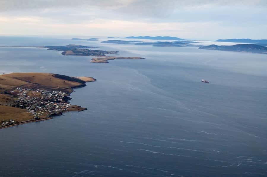
Eastern Shore and the Derwent River: where the best angles start
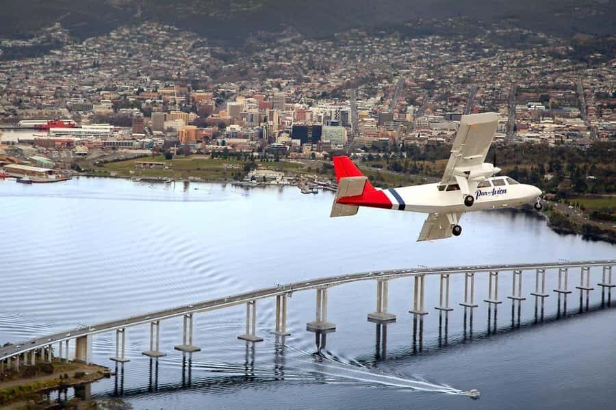
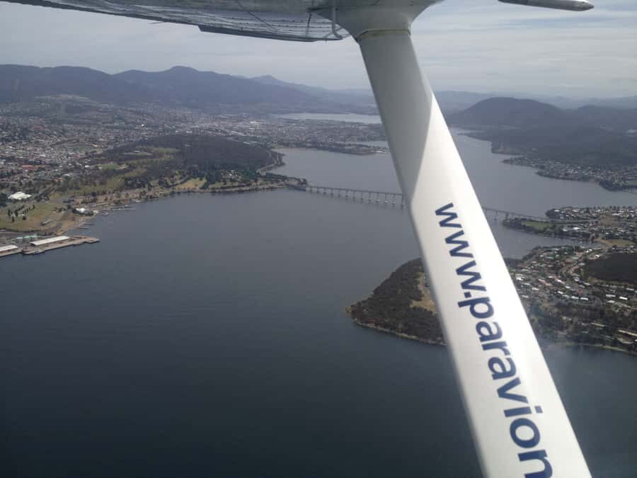
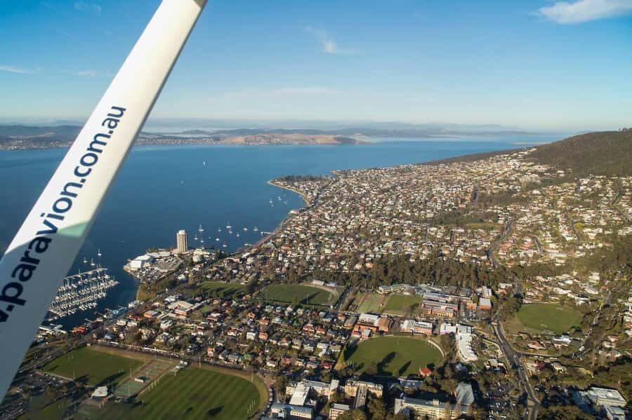
The flight begins by heading out from Cambridge Airport and crossing the Eastern Shore before tracking across the Derwent River. From up high, the river stops being a scenic edge and becomes a map—curves, bridges, and the way settlements line the water all click into place fast.
You’ll get to see the river and its bridges, including Tasman Bridge. Watching it from the air is different from standing on the ground: you get a sense of how the bridge connects neighborhoods and how the coastline bends around it.
This is also when photos tend to come together. If you like picture-taking, I’d treat the early part as your “get oriented” section. You’ll spot the river’s flow, then the city forms around it, and you can start anticipating what’s next.
Up the river: MONA and Hobart’s Northern Suburbs in context
As the plane works its way up river, you’ll pass toward MONA (the Museum of Old and New Art) and the Northern Suburbs. Seeing MONA from above is oddly satisfying: it lands in the wider city picture instead of feeling like a destination you drive to and forget about.
More importantly, the Northern Suburbs look different from the sky. Patterns you wouldn’t notice from street level—where the built-up areas stretch, where they thin out, and how the river corridors shape development—show up clearly.
If you’re the type who likes cities with a story, this section helps. It’s not just a landmark checklist. You’re watching how Hobart’s layout responds to water, elevation, and the long view along the Derwent.
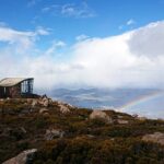
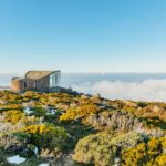
Mount Wellington framing the city: kunanyi from 1270m
Then the flight turns so you can line up with Mount Wellington, also known as kunanyi. At 1270m, it’s a dramatic presence even when you’re looking at it from town, but from the air it becomes a real backdrop to the entire scene.
In winter, the rugged peaks are often dusted with snow. That detail isn’t just interesting trivia—it’s the kind of difference that can make the flight feel like a special moment rather than the same view you’ve already seen from a lookout.
This is the part I’d prioritize emotionally, even if you’re not a mountain person. Hobart’s charm is the mix: water, city, and a giant natural wall behind it. From the cockpit view, you get that “three layers at once” feeling fast.
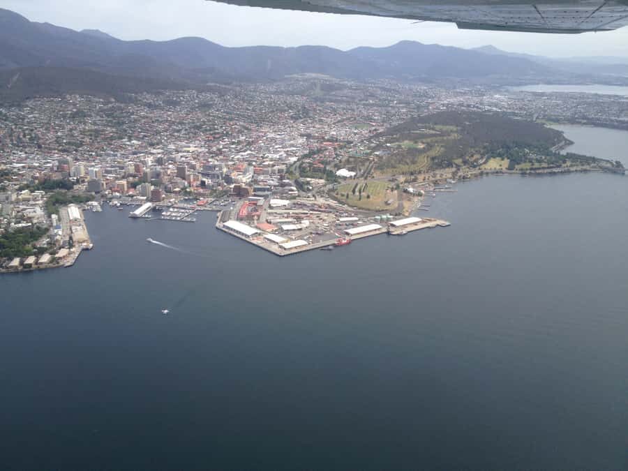
Over Hobart city and the harbor: what you’re really seeing
Once you fly over Hobart City and the harbor area, you stop looking at the city as separate suburbs and start seeing the whole system. Ports, shorelines, and the way land meets water become the main characters.
From above, the harbor looks tidy and geometric, but don’t let that fool you. The real value is understanding where you are relative to everything else. If you’ve been walking around town, this is the moment that helps you get your bearings fast.
One practical tip: keep your camera ready, but also take a minute to just look. The harbor view tends to be visually “busy” at first. After a quick scan, it becomes easier to pick out what’s important to you—whether that’s the waterfront, the shape of the bay, or where the city reaches inland.


Kingston, South Arm, and Clifton Beach on the return
The route doesn’t just circle back the way you came. After the city and harbor stretch, you pass Kingston, then South Arm, a coastal community, and then Clifton Beach—a popular surfing location.
This section adds variety. You see a more residential-and-coastal rhythm compared with central Hobart. South Arm, in particular, gives you a sense of what the water-facing life looks like when it’s less about the core and more about the coastline.
Clifton Beach is another nice touch because it gives the “Tasmania beyond the city” feeling. Even if you don’t surf, you’ll likely recognize why it’s known: the beach setting reads clearly from above, and you can see how the coastline is shaped for those waves.
If you live in Hobart, there’s a good chance the pilot will do their best to fly overhead of recognizable areas. In one recent case, that effort and the pilot’s competence were called out directly, which tells you the crew really does care about the experience.
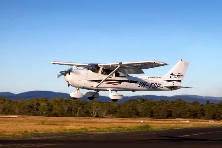
Aircraft choice and group size: why it can feel different
The aircraft type varies depending on group size. That doesn’t sound glamorous, but it matters for your expectations.
Different aircraft can change how tight the cabin feels and how the windows look. The good news: the flight is still a 30-minute scenic route with the same key view targets—river, bridges, MONA area, Mount Wellington, Hobart, and the return coastal stretch.
So if you’re booking, I’d focus less on the exact model and more on the promise: you’re buying time in the sky over Hobart’s most distinctive features.
Price and value: is $140 for 30 minutes fair?
At $140 per person for 30 minutes, this isn’t an “economy sightseeing bargain.” It’s closer to a pay-for-the-window seat kind of value: you’re paying for a viewpoint that’s otherwise hard to access without a helicopter or hours of travel.
Here’s why I think it can still be good value:
You’re not spending time getting to multiple locations. The flight strings together the Derwent River, Tasman Bridge, MONA, Mount Wellington, the city, and the coastal communities, all in one compact run.
You’re also getting the pilot’s perspective plus commentary. A number of recent guests highlighted that the pilot was both competent and friendly, and one pilot named Theo was praised for skill and interesting narration. That human element matters because it turns a pretty view into something you understand.
The only reason it might not feel worth it for you is if you need more time on the ground or you’re expecting a guided tour with stops and photo walks. This is simply a scenic flight from above.
Best for short visits, locals who want a new angle, and photo-minded people
This works great for first-time visitors who want a quick “read” on Hobart. After a flight like this, it’s easier to connect what you saw in town—streets, waterfront areas, and the mountain—because your brain now has the larger shape.
Locals also tend to like it. Even if you think you know the city well, flying over Hobart City, the harbor, Kingston, and South Arm can reveal angles you don’t normally notice. And since the pilot tries to fly overhead where possible, it feels a bit more personal than generic sightseeing.
It’s also a solid choice for travelers who want something special without committing to a full-day plan. Thirty minutes is short enough to fit almost anywhere, and long enough to matter.
A quick practical checklist before you go
Keep your expectations realistic: you’re seeing a lot quickly from the air. If weather is clear, you’ll likely get the strongest views, and in winter you may be in the right season for the snow-dusted Mount Wellington effect.
Bring layers if you’re going in colder months, because aircraft cabins and airport areas can feel brisk. If you’re planning to take photos, have your phone charged and consider wiping your camera lens—small fixes help in a window seat situation.
Most of all, arrive early and settle in. When you’re not rushing, it’s easier to enjoy the commentary and notice details as they appear.
Should you book this 30-minute Hobart scenic flight?
Yes, if you want a fast, high-impact way to understand Hobart from above. The combination of the Derwent River, Tasman Bridge, MONA, and Mount Wellington gives you a city-and-nature picture you can’t replicate from one lookout. Add in pilot commentary—praised for friendliness and competence in recent feedback—and you’ve got more than a passive sightseeing moment.
Skip it only if you’re the type who wants ground time, walking, or stop-and-start touring. This one is about the sky view, plain and simple.
If you’re debating whether to do it with limited time, I’d lean toward yes. Hobart rewards you best when you see how the pieces connect.
FAQ
How long is the scenic Hobart plane flight?
It’s a 30-minute scenic flight.
Where does the flight depart from?
The meeting point is Cambridge Aerodrome, 115 Kennedy Dr, Cambridge TAS 7170.
What areas are you flying over during the flight?
You’ll depart Cambridge, fly over the Eastern Shore, cross the Derwent River (including Tasman Bridge), continue upriver toward MONA and the Northern Suburbs, then fly down past Mt Wellington, over Hobart City and the harbor, and return past Kingston, South Arm, and Clifton Beach.
What makes Mount Wellington special on this route?
You fly past Mount Wellington (kunanyi), which is 1270m high. In winter, its peaks are often dusted with snow.
How much does it cost?
The price is $140 per person.
Do I need to arrive early?
Yes. You should arrive at the airport at least 30 minutes before departure.
Is it possible to cancel for a refund?
Yes. There is free cancellation up to 24 hours in advance for a full refund.